
Kerman
Rayen
Die Lehmziegelzitadelle, die dem Erdbeben von Bam entging
 6 Highlights · tippen Sie auf einen Punkt
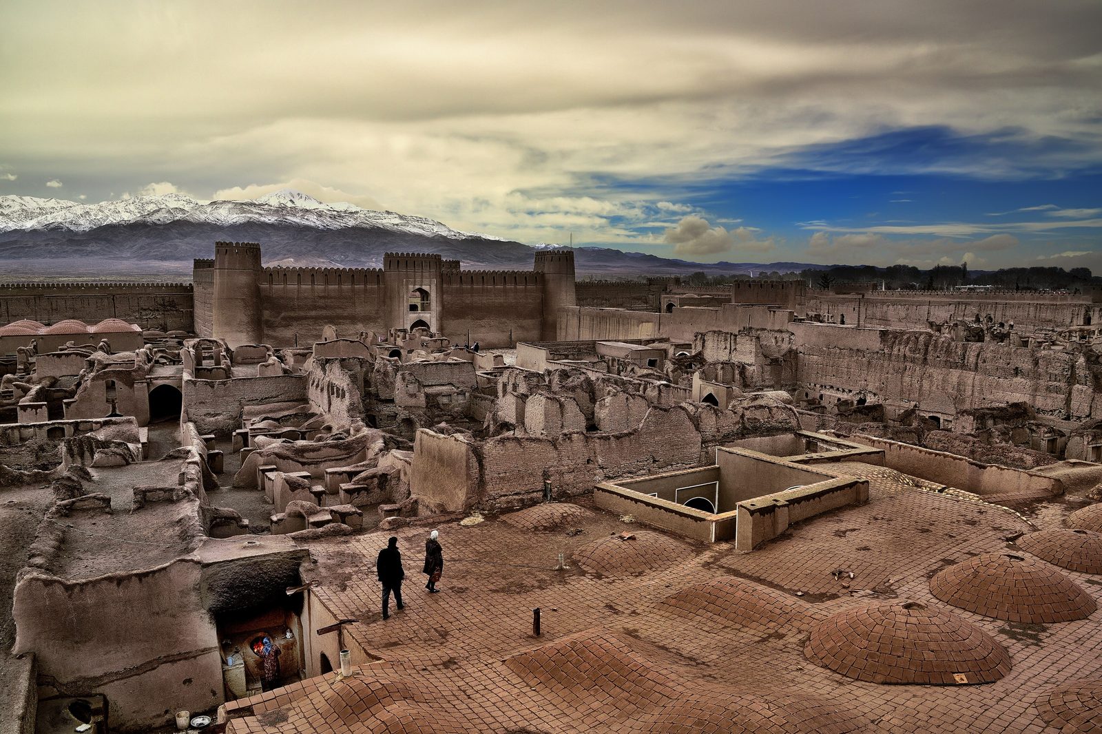
Rayen ist eine kleine Hochlandstadt rund 100 km südlich von Kerman, gelegen auf etwa 2.200 m Höhe am Fuß des Mount Hezar, des höchsten Gipfels im Süden Irans. Geprägt wird der Ort von Arg-e Rayen (der Zitadelle von Rayen), einer weitläufigen Lehmziegelfestung von über 22.000 Quadratmetern, die vielfach als zweitgrößte Lehmfestung der Welt nach Arg-e Bam bezeichnet wird. Sie ruht vermutlich auf Fundamenten aus sassanidischer Zeit und war bis 1868 bewohnt; das Erdbeben von 2003, das Bam verwüstete, überstand sie und zählt damit zu den besterhaltenen Beispielen traditioneller iranischer Militär- und Stadtarchitektur. Die umliegende Region bietet zudem Wasserfälle am Wüstenrand, Mineralquellen, Walnusshaine und eine lebendige Tradition der Messerschmiedekunst.
Nächste 5 Tage
Top-Sehenswürdigkeiten
- 1
Arg-e Rayen (Rayen Castle)
Vast well-preserved medieval mud-brick citadel of over 22,000 m2, second-largest adobe fortress after Bam. One of the world's largest and best-preserved adobe citadels; survived the quake that destroyed Bam, preserving a near-complete picture of traditional Iranian fortress-town design.
- Wo
- Rayen town center
- Zeitbedarf
- 1.5-2.5 hours
- Öffnungszeiten
- Daytime visiting with an entrance fee; exact hours and ticket price change seasonally — verify before travel.
- 2
Governor's Quarter (Khan-Neshin / inner castle)
Fortified inner castle with watchtowers that housed the governor and administration. Shows classic Persian four-iwan layout around a central courtyard — the elite, defensible core of the citadel.
- Wo
- Inside Arg-e Rayen
- Zeitbedarf
- 20-30 minutes
- Öffnungszeiten
- Accessed within the main citadel ticket; verify before travel.
- 3
Zoorkhaneh & former fire temple
Small domed structure that was a Zoroastrian fire temple, later converted to a traditional Persian gymnasium. Tangible record of the citadel's pre-Islamic-to-Islamic transition and of varzesh-e bastani heritage.
- Wo
- Inside Arg-e Rayen
- Zeitbedarf
- 10-15 minutes
- Öffnungszeiten
- Within the citadel grounds; verify before travel.
- 4
Commoners' & artisans' quarters (Aameh-Neshin / A'yan-Neshin)
Residential and craft districts laid out by social class, with stables, mosque and workshops. Illustrates how a self-contained fortified town separated merchants, farmers, craftsmen, clergy and notables.
- Wo
- Inside Arg-e Rayen
- Zeitbedarf
- 20-30 minutes
- Öffnungszeiten
- Within the citadel grounds; verify before travel.
- 5
Rayen Waterfall (Zar Roud)
Waterfall on the Zar Roud River about 14 km southwest of town in the Mount Hezar foothills. Snow-fed cascade and river in an otherwise desert-edge region; popular green retreat in spring and summer.
- Wo
- Hezar foothills, SW of Rayen
- Zeitbedarf
- Half day with the drive/walk
- Öffnungszeiten
- Outdoor natural site; best flow after snowmelt — verify road and water conditions before travel.
- 6
Mount Hezar foothill villages
Cool green villages at the base of Mount Hezar (4,501 m), southern Iran's highest peak. Mild summer climate, orchards and mineral springs make Rayen a 'desert paradise'; gateway to highland trekking.
- Wo
- South/southwest of Rayen
- Zeitbedarf
- Half to full day
- Öffnungszeiten
- Mountain area; conditions and access vary by season — verify before travel.