
Kerman
Dasht-e Lut (Kaluts of Shahdad)
Der heißeste Ort der Erde, wo vom Wind geformte Sandstädte auf den dunkelsten Wüstenhimmel treffen
 8 Highlights · tippen Sie auf einen Punkt
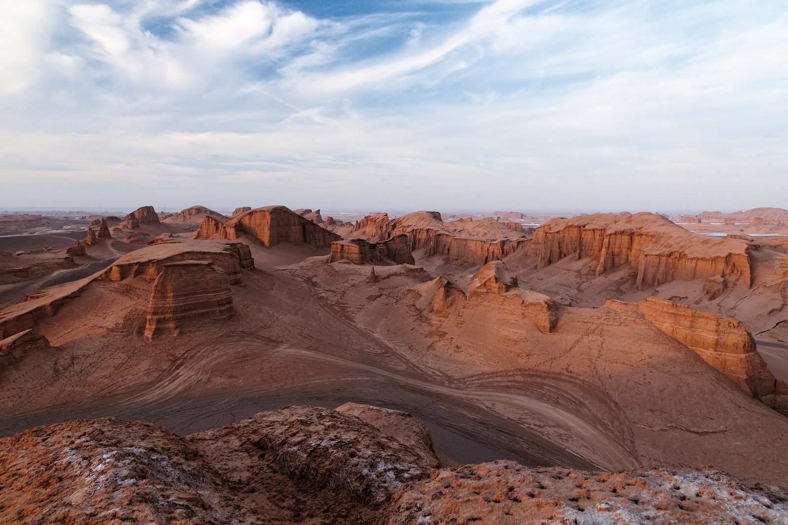
Die Dasht-e Lut ist eine ausgedehnte iranische Wüste in den Provinzen Kerman und Sistan-Belutschistan, 2016 als erste natürliche UNESCO-Welterbestätte Irans eingeschrieben — wegen ihrer außergewöhnlichen Yardang-Formationen und der bis heute wirkenden Winderosionsgeologie. Ihr Wahrzeichen sind die Kaluts (Kalut/Yardang) nahe der Oasenstadt Shahdad, dem Tor zur Wüste: ein Labyrinth aufragender, vom Wind geformter Rücken, die einer Ruinenstadt gleichen. Satelliten haben hier wiederholt die weltweit höchsten je gemessenen Landoberflächentemperaturen erfasst. Über die Geologie hinaus bietet die Lut einen der dunkelsten Nachthimmel der Erde zum Sternebeobachten, gewaltige Sandmeere, Nebka-Hügel, Salzflüsse und bronzezeitliche Archäologie im Umfeld der Shahdad-Kultur und der weiteren Jiroft-Zivilisation. Sie ist weniger eine gewöhnliche Stadt als ein erstaunliches Reiseziel geologischer Superlative.
Nächste 5 Tage
Top-Sehenswürdigkeiten
- 1
Kaluts of Shahdad (Kalut yardang field)
Vast field of wind-carved sand-and-clay ridges resembling a ruined desert city, the heart of the Lut UNESCO site. One of the largest yardang landscapes on Earth; ridges run parallel to the prevailing wind, reaching up to about 75-155 m in height and traceable for tens of kilometers. The signature image of the Lut Desert.
- Wo
- Lut Desert, NE of Shahdad
- Zeitbedarf
- Half to full day (sunset essential)
- Öffnungszeiten
- Open landscape, no formal gate; access via Shahdad-Nehbandan road roughly 40 km past Shahdad. Verify road and guide/4x4 requirements before travel.
- 2
Lut night sky / stargazing zone
Among the darkest skies in Iran, with the Milky Way and faint deep-sky objects visible to the naked eye. Near-zero light pollution makes the Lut a premier astrotourism site; desert camps walk guests beyond camp lights for Milky Way and meteor viewing.
- Wo
- Open desert around the Kaluts
- Zeitbedarf
- Overnight
- Öffnungszeiten
- Best near new moon; bring warm layers as desert nights are cold. Verify camp availability before travel.
- 3
Nebka (Nabkha) mounds plain
Vase-shaped sand hummocks built up around desert vegetation, some reaching around 10 m tall. A distinctive Lut landform en route to the Kaluts; an early stage of dune formation that contrasts with the giant yardangs further in.
- Wo
- Between Shahdad and the Kaluts
- Zeitbedarf
- 30-60 minutes
- Öffnungszeiten
- Roadside stop on the desert approach; verify access with a local guide.
- 4
Shafiabad Caravanserai
Historic mud-brick Qajar-era caravanserai in Shafiabad village, the last oasis before the deep desert. Atmospheric corner-towered desert waystation marking the historic edge of habitation before the Kaluts; a classic photo and rest stop.
- Wo
- Shafiabad village, Shahdad District
- Zeitbedarf
- 30-45 minutes
- Öffnungszeiten
- Hours informal; verify before travel.
- 5
Rig-e Yalan sand sea
Enormous dune field in the southeastern Lut with some of the tallest dunes on Earth (up to roughly 300 m). A remote, expedition-grade sand sea showcasing the Lut's giant aeolian dunes; reachable only by serious off-road desert crossing.
- Wo
- Southeastern Lut Desert
- Zeitbedarf
- Multi-day expedition
- Öffnungszeiten
- Deep wilderness; requires experienced guide, multiple 4x4s and full self-sufficiency. Verify logistics and safety before travel.
- 6
Gandom Beryan plateau
Dark basaltic 'Plain of Toasted Wheat' historically cited among the hottest spots in the Lut. A black volcanic lava plateau whose name reflects local lore of extreme heat; associated with the desert's record surface temperatures.
- Wo
- Central-northern Lut Desert
- Zeitbedarf
- Part of a multi-day desert tour
- Öffnungszeiten
- Very remote, no facilities; guided 4x4 only. Coordinates approximate, verify before travel.
- 7
Shahdad town and palm oasis
Gateway oasis town to the Lut, with date palm groves, qanats and a Bronze Age archaeological legacy. Main staging point for Kalut trips (about 95-99 km NE of Kerman city); home to the Shahdad culture finds including the ancient bronze standard.
- Wo
- Shahdad District, Kerman County
- Zeitbedarf
- 1-2 hours / base for the night
- Öffnungszeiten
- Town services limited; stock water/fuel here before entering the desert.
- 8
Salt River (Rud-e Shur)
Seasonal salt-laden river and salt flats threading the Lut near Shahdad. Glistening saline channels and crusts add to the otherworldly Lut scenery and feature on most Kalut day-tour itineraries.
- Wo
- Shahdad desert approach
- Zeitbedarf
- Short stop
- Öffnungszeiten
- Conditions vary seasonally; verify with guide.
- 9
Shahdad Kalouts (Lut Desert)
The 'natural sandcastles' of the UNESCO Lut Desert — giant wind-carved yardangs near Kerman. UNESCO Lut Desert's signature landscape; Earth's hottest recorded surface.
- Zeitbedarf
- Half day to overnight